The yard is in the tropics. There are 2 seasons wet and dry. Its ranges a wet and muggy 32 C in Summer to great sunny dry 25 C in winter months. The prevailing sea breeze is 10-25 knots from the NE-SE most of the time, with more northerlies in summer months.
The Townsville area is in the cyclone belt and the season is from November to March each year. With the onset of the cyclone season, most blue-water cruising yachts head south to ports South of Gladstone (tropic of Capricorn). For those with roots in the area, then the location of the mooring and the knowledge of local cyclone bolt-holes is important.
Weather forecasts are very important at this time. Usually the Bureau of Meteorology (BOM) Qld weather and warnings is a good site.
In more recent times weather apps for smart-phones like "windy" or "Predict wind" have good animations that can forecast budding cyclones upto about a week ahead.


2 - 5 months later: April - June. Public parks and beaches restored.
 We didn't know much about this system before TC Yasi. Later we found that we were in a yellow evacuation zone (moderate risk) during this cyclone. The government sends out messages on radio, TV, internet and even text messages to mobiles about which zones should evacuate prior to the storm reaching the coast.

TC Yasi on 1st February 2011
The summer of 2010/2011 was a very wet and disastrous LaNina driven wet season. Some huge flood events ripped through many parts of Queensland and these were topped off by a monster-cyclone, Yasi.
TC Yasi's eye crossed the North Queensland coast at Mission Beach on Wed 2 Feb 2011 around 11pm. Wind speeds reached over 280 km/hr (Category 5) near the center. Mission Beach is 110 km south of Cairns, 165 km NNW of Townsville and 130 km north of the wyloyard.
Normally cyclones destructive zones are about 50-100 km wide, so there is far more chance of a cyclone missing your area. This time Yasi's destructive zone was 300-400 km wide and it penetrated hundreds of km inland as well. It cause widespread destruction along the coast and inland. This destruction was aided by allot of soft soaked ground from months of extreme rains and floods before Yasi hit. It was far easier than normal for ground to wash away along roads or bridges or for large trees to be uprooted.
The BOM has a cyclone information page. Our cyclone windspeed severity "Category" system is different from the USA's hurricane category system.
Cylone preparations are important.
At the start of the cylone season, as usual, i read the BOMs and councils advice on line and prepared a cyclone kit to the recommendations. It was prepared in case of storm-surge evacuation order from the State government. It consists of one 48 litre plastic box filled with matches, lighters, candles, small radio, batteries, torches, duct tape, garbage liners, Trangia stove and methylated spirit fuel, zip-lock bags of various sizes held small items such as matches and batteries. Tinned and dried foods for 4 days made up the remainder. It's small enough to carry to an evacuation center in a hurry or to fit in the cyclone room at home.
Other preparation for the flat we called home. Gas cooker, about 2 weeks of tinned and dried food, 1-2 days worth of ice in freezer, about 10 plastic storage boxes, several plastic Jerry cans and a collection of empty plastic juice bottles. Brought spare tarps and a roll with 200m of 9mm rope down from the yard (in case of de-roofing). These things MUST be bought-collected well in advance for when the cyclones bearing down on you and in the days-weeks of aftermath it very hard to impossible to buy these items anywhere. In the garden i cleared the storm water drain (for the down-pipes runoff ) which the body corporate's fast buck lawn-mowing leaf-blowers had forgotten about for a few years. In addition, we each had a boating life-jacket incase of flooding.
Studied cyclone behavior for our region. Here in the southern hemisphere cyclones rotate counter-clockwise around an "eye" and generally track west to south. This makes the half semicircle south of the eye far more dangerous with stronger winds and bigger waves than the northern half (called the navigable semi-circle in ship parlance). Fortunately the Great barrier reef, 50-80 kms offshore, dissipates most of the offshore deep sea wave heights. Townsville also has Cape Bowling green which sweeps out in a protective arc to the east.
In late January, a small cyclone TC Anthony (Cat 1, 63-88km/hr) was already a few days ahead of TC Yasi and was due to strike the North Queensland coast first. So I prepared the wyloyard for both cyclones. Removed anything that could fly from the deck, sheds and around the boat and stored it inside. Loose sheets of corrugated iron were stacked in piles on the ground and held down by heavy (18-25kg) pieces of ex-railway line. The 2 vans were tarped (16x8 to fit) with guys on every lug. They were already wired down to concrete footings and were weighted with a fair bit of gear. Good equipment put up higher, waterproof stuff on the floor.
The wylo's windward ports were covered with sheet metal bolted on, the heavy temporary construction hatches bolted down with 1/2'' threaded rod to 2x3 timber under the inner coamings. Lee portholes were taped shut (must get the real ports done one day!). The 2 windsurfers hanging under the roof were heavily lashed to the shed framework. All 3 external shade-rain tarps were taken down.
TC Anthony's track changed and it veered to the south, crossing the coast at Bowen on Sun 30th January. It hit Hamilton Island in the Whitsundays with 125km/hr winds but they came though with tree branches down and not too much rain in it.
Mon 31st Jan
I went out bush to work at Mt Coolon, (200km west of Mackay) where The low of ex-TC Anthony had had tracked through the day before (it was very soggy!) Before driving out bush, the BOM track map showed Yasi was brewing near Fiji and moving west, we weren't too sure if we were going the right way..! (Highways outback usually get cut off by flooded rivers during cyclones or tropical lows, ie. You get stranded in the middle of nowhere for a week or so)
At Mt Coolon, we saw that the US Navy joint typhoon warning centers track map was updated and TC Yasi forecast track was between Cape Melville and Mackay but the eye track line then headed right for Ingham about 50 km north of the wyloyard.! Predicted to be pretty strong. Thanks for the early warning JTWC! Most of the camp's crew applied for work leave and thankfully it was granted.
 |
| TC Yasi forecast path, JTWC. |
 |
| TC Yasi predicted path and size, 4am Feb 1st 2011, BOM. |
Tues 1st Feb
We headed off at 12noon for the 5 hour drive back to Townsville via Charters Towers. A bit unsettling as the route was straight towards TC Yasis predicted path, (usually most people drive away from huge once a century cyclones!) It was hard to think about much else except get back home and survive it. The BOM's track map predicted land fall near Cairns at Cat 4. Unknown to us at the time, a huge evacuation of coastal areas led by the government was already underway. "Cyclone watch" extended from Cape Melville to Yepoon, areas 1,200 km apart. This means prepare well in advance.
But we had already run out of that prep time. We arrived home in Townsville at 5pm on 1st Feb. The final cyclone-evacuation train had already left Townsville for Brisbane at 4pm, all trains were stopped. Last flights were fully booked up and the Airport was to shut down. Hasty preparations were made as Yasi intensified to a forecast Category 4 or 5. It 's predicted landfall crept further south, towards us, which is often the case. (Cairns got lucky, their CBD is only 2m above highest tide)
Wed 2nd Feb - Prepping
It was now becoming too late to evacuate by road. The TV news kept us updated, highways were still pretty busy with fleeing vehicles and it's the worst place to break down and get stuck in it. Most homes around us were already evacuated, some boarded up with plywood sheets, the empty streets were eerily quiet. About 70,000 people were told to evacuate from the low lying coastal suburb areas. A color coded scheme indicated how dangerous each zone was. I checked the councils predicted storm surge map at 2pm, it showed that a 2.7m surge could engulf about a third of the citys coastal suburbs and our street was just inside the edge of that theoretical sea, 3 km inland! That was a shock, too late to leave, so sat there for about 10 minutes in stunned silence. The flat was ground level, not good.. That's why everyone likes high-set houses around here, and why 3 out of 5 households in our lowset flats block had already evacuated. Just the newbies were left! All the locals were gone!
With evacuations if you leave it too late the choices become very limited. Move the higher ground/secure building or stay put. Friends houses inland were already full. Phoned the State Emergency service/Government who said that their evacuation centers inside the city suburbs were already full of people and were turning more away. Too late for that.
 |
| The predicted 2.7m storm surge map for a 9pm crossing coincident with high tide at 8.45pm. (worst case scenario) Castle Hill - Northward would become an Island. The port, CBD, South Townsville, Railways Estate, Hermit Park, Paleranda , Belgian Gardens, Horseshoe bay on Magnetic Island and parts of Pimlico-currajong-Wulguru-Onoonba were predicted to be inundated by storm surge. (This was the basis for about 70,000 residents taking evacuation action) |
"Riding it out" at home was the only option remaining with only hours to go. Did some life-jacket training, we all had 3m ropes tied to each jacket to stay together or tie onto secure objects if a storm surge flooded us.
At home final disaster prepping was done. Water supply, every spare container was filled up. Jerry cans, bottles, buckets, laundry tub, bath tub - you name it. The plate glass windows were criss-crossed with tape (to prevent shattering inwards). Food stocks, emergency lights, transistor radio, camping gear.
The "cyclone rooms" were prepared (bunker?) These are the rooms with most chance of remaining intact. The small bed room was located at the predicted leeward side and had only one window and a wooden door. So all valuables were put in 48-52 liter plastic boxes, the most valuable items like files-electrical equipment etc on-top. The very important documents went in a sealed bag, in a day pack, in a plastic box on top of the fridge in its alcove. (Incase it flooded 3-5 foot deep in there).
The smaller bathroom was also prepared to stay in. Cyclone kit box in there, mats, water. Being the smallest room its also reportedly the safest room of a dwelling, especially if the roof starts lifting off.
We had confidence in the apartments strength. Hollow concrete block walls held together by rods set in concrete fill. These steel rods also hold the roof frame onto the concrete slab foundation. Cyclone area building regulations.
Parked the cars undercover, allot of empty carports luckily, so flying debris wouldn't smash them later. Wheelie bins were bought in and lashed to a leeward courtyard fence. The Army choppers busy all day then returned to their secure hangars at the base.
Making up sand-bags for flood levees was also no go in the final prepping hours. Too risky to drive 2km over to the bagging site, what if the car broke down? So improvised and caulked up the 2 doors with rope and scrap cloth, like wooden boats seams, so it might keep flood waters out a bit, (until the window sill level was reached at least..)
TC Yasi hits land
At 4 pm 2nd Feb the first winds started. Trees began to thrash about. At 5 pm i went to the secure car-park just as the for sale sign flew horizontally away down the street (never to be seen again). Darkness fell about 6.30 pm. This gave more time to batten down further (more window tape, packed more things away) once we could see the first winds were from SSE direction. The more vulnerable lounge room/kitchen areas were emptied of things and moved to safer spots.
Suddenly the predicted storm surge conditions got better! Now the hourly BOM track map update predicted TC Yasi to cross a bit later at around 11 pm, a good thing because this was on a falling tide, low tide equals lower storm surge. The chances of salty floods reaching us were now small, a huge relief. The wind picked up around 10 pm, the flat had a good sheltered courtyard and windward high-set house and high flat on the carports, these acted as wind barriers. The wind mostly howled-roared over the top of us. Occasional gusts or down-bursts turned the courtyard palm trees into writhing things in the veranda light. In the cyclone room i closed the curtains, better not to see those trees getting thrashed.
 |
| BOM track map of TC Yasi at 10pm on Tue 2nd Feb 2011. Last image in just before power blackout and internet went off. The red zone is "very destructive", pale red zone "destructive" (hurricane force, Beaufort scale 12) and pink zone "gale-force" winds. Brown zone is cyclone watch. In Townsville it was estimated to peak out from the East at about 160km/hr . |
The flat was proving to be "rock-solid", no smashing sounds were going on outside. The high rooftops around caused the wind and rain to blow right over. Mobile phones helped compare notes, friends in Currajong a few km away lost power at 8 pm. Wind intensified further after 10 pm, so opened leeward windows to reduce any problems if a windward window failed. This increased the wind noise inside allot, though, it sounded like a jet engines scream. Power blackout and phones went down at 11.30 pm. we lit up the candles and 2 kerosene wick lamps. Turned on the mini radio, the only communications with the world for the next three days. The radio is essential to know whats going on, it became a most valuable piece of the kit. Heard the winds here were about 160 km/hr. It was scary but was so tired fell asleep before the peak of it at 2 am on the 3rd Feb.
Thurs 3rd Feb. - Yasi passes
The dawn saw cyclone strength winds still howling from the East. Remnant stumps of big tree tops stuck up like broken sticks not too far away, the remaining almost leafless branches thrashing erratically Grey skies and some rain but not allot, "only" 165 mm reported, it was a fast moving storm (usually 300-600mm rain falls) Checked and found no damage to the flat, outside the nearby palm trees and mango tree were fine. Further away other trees were broken or toppled over completely. Even palms were not fully exempt, one tall palm fell down over a neighbors shed and fence. Radio reports came in about how the towns water system barely survived, the government advised everyone to stay inside until it was over and conserve water. Still a worry about the 2nd high tide at 9 am, but the second sea surge was small.
The final gale-force winds passed about 3 pm. The city was now silent, all the power was out. Water still going and phones/internet were restored. Cars, mainly 4WD's, began to emerge onto roads, slowly weaving through debris and pools of water. From home we phoned friends to see if everyone was OK and cyclone survival stories emerged.
Up north friends near the wyloyard told that although their house shook allot and the shed flooded they were in one piece. The wyloshed's and my house were still standing! They were very surprised the big boat roof held on (approx 200 km/hr winds there?)
Friends further north at Hencamp creek (closer to the eye) on a farm were OK, they were on solar power and creek water. The outhouse door blew away and a branch fell through the garden shed roof but otherwise ok and 175mm rain fell there. Other friends at a beach-side suburb in Townsville, weren't as lucky, they had evacuated inland and on return found their plate glass windows blown-in and rain damage. The house they'd evacuated to had a big tree come down over the driveway and it missed the lounge room by just 1 meter, lucky.
Put the flats stuff back where it belonged. Its amazing how many things you "loose" for weeks-months afterwards due to the sudden re-packing!
Yasi kept going inland way into the outback causing floods etc and soon reaching mining town Mt Isa, 900km away, still with Cat 1 winds! Normally cyclones die out into rain depressions only 100km from the coast. Yasi had a huge amount of kinetic energy in it to keep blowing hard that far inland, never seen or heard of that before.
Fri 4th Feb - Aftermath
Next day before i went for mountain-bike ride in Pimlico to see what was happening. Trees litter the streets but house roofs were still on. The mini mart was on gen-set and people flocked there for rationed fuel and supplies. Open areas like parks lost allot of trees and some houses at their edges got minor structural damage (saw one veranda plus steps torn off). The N-S streets coped far more tree damage (SSE wind) and the E-W streets like ours less tree damage. It was safer to be in built-up areas where the wind damage was less. Open areas like parks must have had stronger winds, more trees were down.
 |
| Gill Park, Pimlico, Townsville. Fallen trees. |
 |
| Gill Park, Pimlico, Townsville. Sports shelter damage. |
The radio advised people stay home and off roads so emergency crews could work.

An Ergon energy "cherry picker" truck crew surveying the street for damaged power-lines.
However, we needed ice to keep the fridges frozen food cold in the esky. Drove to the Tropical Ice factory to get 6 bags of ice. They had generator backup power and were selling ice fast, very efficient service, lots of people were going there. Even though the que of people was about 50m long it only took 5 minutes to get some ice.
70,000 (most) homes in town were without power. The first job for Ergon energy was to save the town water supply systems and chlorination plant also essential services locations.
The air was again filled with the sounds of Army and News helicopters. Many were heading north where the disaster aftermath was far worse. Townsville was virtually cut-off from outside. Road, rail, sea and commercial air services halted.
All highways were cut by flood damage. The bruce Highway was down North and South of us (near Ayr and Ingham). A very long convoy of re-supply semi's was backed up about 100kms south, waiting for highway repairs. The only remaining third inland route was also cut off. The Macrossan bridge crossing on the Burdekin river was 5 m over. The bridge is 17m above the riverbed. River here is 150 m wide. Upstream, the Burdekin falls dam was 4.7 m over the spillway, allot of water. Thousands of drive-evac people were stranded in hotels far from home took a few days for it to re-open. We were now glad to be at home (our neighbor took a week to get back in from car evacuating over 500km away, due to bridge and highways washout damage) Supermarket shelves were fast becoming bare, (but no worries if the food and supplies prepping was done early.)
People cleared the green debris from their sections and made large piles on the nature strips for pick up (1-4 weeks estimated). Did the flats gardening, fallen fronds and small branches. Good chance for some preventative pruning too. People were returning to the flats from their evacuation houses.
The Townsville seaport reopened and the first re-supply ship arrived. The city was still on water restrictions, cooking and hygiene only. Ban on outdoor usage because the header reservoirs were almost drained and difficult to refill, on the verge of town water shut down.
Magnetic Island got hammered harder than us. No power, water or telephones still. Generally the further a place is from a city, the slower it is to get essential services restored.
Sat 5th Feb - Aftermath
Cool heavy rains fell early. City of Mackay's power back on (4 hr drive south) trees on roads were being pushed aside. The highway opened from Ayr (100 km south) and Ergon's huge repair truck convoy from Brisbane made it through to Townsville.
We visited the ice factory, this time rationed to 3 bags per adult, faster and more efficient. Herculean workers who had done this continuously for days in the very hot sun, handed over ice bags faster than you could think about it.
Trees were now all pushed off to the sides of roads. Noticed alot of signs were damaged, bent or down
 |
| McDonalds sign damage, Garbutt. |
Power poles were very stout too and hardly any went over, only if a big tree landed on them. Mostly trees had landed on power-lines to bring them down.
Suddenly, electrical power came back on at 5pm!! A big cheer. The power-line and electricity repair crews did a great job. TV news images showed some of the real damage up north between Cardwell and Innisfail. We saw Tony Abott, Federal government opposition leader at the time (and later Prime Minister of Australia from 2013-2015) on the TV news grabbing a few bags of ice at the local ice factory too (perhaps a good PR op!?) Coastal beach areas were severely damaged, sand was pushed back by storm tides and covered foreshore roads and beachside properties. Townsville's strand foreshore parks and road were a mess, covered in sand and debris.
Sun 6th Feb - Aftermath country side
We headed up to the wyloyard 50km north, for the first visit. The Ergon helicopter crew was surveying the power-lines for damage, the power was still off. Army trucks and soldiers helping the elderly clean up. Took 3 esky's full of leftover ice-bags up, gave some to a bobcat on the road, some friends and left the rest at mates with a gen-set and big freezer for the local chainsaw crews. It was very hot, extremely humid and sweltering as all the moisture was evaporating in a blazing sun and there was little breeze. Fortunately no houses in the area lost their roofs or got flooded. Estimated TC yasi winds were probably about 120-180 km/hr (about Category 3)
 |
| Helicopter inspecting high voltage powerlines tower |
 |
| A large fallen tree near Rollingstone |
Fortunately and kindly some neighbors had petrol chainsaws, 4WDs and trailers and had cleared 3 fallen trees off my wyloyards - house main driveway early on.
 |
| Neighbor Bob's letterbox and tree indicate which way the wind blew |
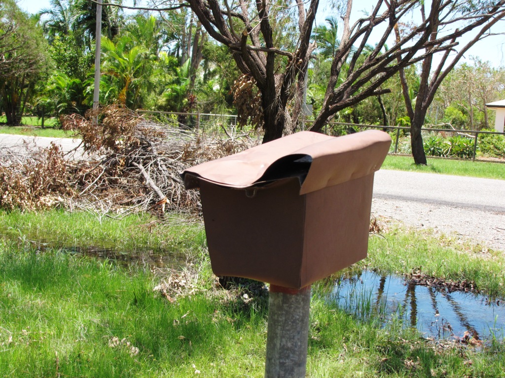 |
| My letterbox |
 |
| Neighbors big tree down |
A tree that bent my letterbox also blocked my driveway entrance. The bigger they are the harder they fall they say. The la Nina wet season has caused unusually heavier rainfall for the last 6 months, this has saturated and greatly softened the clay soil which makes up much of the coastal plains in this region.
Allot of trees or branches came down in the wyloyard forest. Tree trunks snapping off half way down like this was a common sight.
 |
| Tree tops snapped off |
Luckily no trees fell on sheds or vans, but i had done allot of tree clearing near the boat over the years to prevent this happening.

The shed, trees and wall before TC Yasi hit.
 |
| Wylo shed after Yasi |
After Yasi, the yards construction wall fell was demolished. The Remaining branch of the west shed shade tree indicates the cyclonic wind direction. Interestingly paperbarks stood up quite well, lost allot of leaves and smaller branches but rarely fell or snapped their trunk.
 |
| Inspecting damage |
The demolished wall, leaf and twig litter everywhere. The A-frame pieces were lashed to bulwarks.
 |
| Wylo yard tree damaged. Lucky the caravans survived. |
My favorite west-wylo shade tree lost its main top, the trunk snapped off about 4m above the ground Allot hotter on deck in the afternoons for awhile.
I'd positioned the vans of the west side of the tool shed and steel hull, the usual leeward side if the eye passes north. The vans are secured with wire and turnbuckles to eyes in concrete footings. I was amazed the van roof tarps were fine. The tool (garden) shed is council approved Cat 2, it has internal framework and is dynabolted to its slab.
The big shed over the hull has no walls hence reduced side-loading, the roof is sloped gently towards the East, the likely strongest wind directions being SSE-NNE. In these directions the big flat roof acted like a down-force airfoil on a race-car. Just hope it doesn't blow the other way one day! (if the eye passes south, but high mountains to west should kill the winds a bit) The roof was also double tek screwed and all the braced framework and joins beefed up. The lean-to steel roof held, it was a bit under battened but the slope angle must have been right.
 |
| Trees damaged in front yard |
Trees snapped off 3-4 m up next to the tool shed. Luckily the wind blew parallel to the shed at the time. So the Caravan was in its lee too. About 50-60% of the trees foliation was stripped off.
The Wylo itself looked like nothing had happened to it. A few leaves in bulwarks and 1 liter of water in the bilge sump. I reckon it would have been a safe place to be. The windsurfers were still there in their lashings.even the bin i forgot about was still there, filled with water enough to stay put and the lid flipped to safety behind the rudder. No sign of the vice cover.
Rigged the hammock on the boat deck for breaks.With no power, it was just raking, pruning shears, barrow and axe to make piles of branches. Dragged many branches out the driveway to the roadside as others had done along the road. Confused wasps attacked me so left that fallen tree!

Trees damaged, stripped and down in front yard
Very weary to heat exhausted by the end of day, met a few friends and a late afternoon downpour was enough for the army personnel helping elderly residents clear debris, so we followed suit and headed home to Townsville for a rest day with airconditioners to cool off. Schools and other public facilites began to re-open again.
Tues 8th Feb
Headed off wyloyard cleanup day 2. Still no power, so more pruning shears and branch piles along the western wyloforest edge where trees had toppled into Bobs paddock.
 |
| My house (left) and Bob's hut (right) were ok |
Fortunately the houses and sheds in the area are built very strongly/ beefed up to withstand cyclonic winds upto about Category 4. They are about 2-3 times stronger than non-tropical buildings, south of the tropic of Capricorn (around Rockhampton).
Since cyclone Tracy in Darwin 1974 and Cyclone Althea in Townsville in 1970 allot of research was done and applied to building construction regulations. My house at wyloyard is a re-located 1950s wooden house which got a complete cyclone structural upgrade to council regulations when it was re located by semi-truck and re-stumped on site. The builders removed the roof iron, augered holes from the top plate to bottom plate for long 12 mm diam threaded rods to hold the wall together in case of extreme pull-apart forces generated by a cyclonic wind. I also opted for double the number of tek screws to re-fasten the roof iron (it was already double purlined). Below the 0.9m high floor, steel piles are cemented into 1.4m deep augered footings holes. The each pile has a top flange with 2 heavy bolts through the bottom plate frame timber. The frames are all bolted together. The house was reported to be rock-solid with no shaking in the peak cyclone winds. Also old style casement/pane or louvered windows are probably stronger than modern plate glass ones, as each window pane, in a wooden frame, has a small area (about 30 x 40cm each pane)
Bob's weekender next door is steel framed. He's a builder by trade and there isn't any structural damage. He has steel louvered windows upwind side of house, and a strong steel shed on raised slab. No big trees are near house. It was fine.
 |
| Large piles of dead tree branches at roadside for removal. |
The piles out the front are growing, hard work hauling all those branches out to the roadside by hand. Awaiting council trucks to pick it up but that could take weeks (months?)as the scale and area covered by TC Yasi is so large and high priorities like essential services, schools, work and urban areas must be cleared first.

More piles of cut branches. Steel sheds stood up to the winds.
One local heard that his brother-in-laws yacht sank at Cardwell in Port Hinchinbrook further north. It got skewered on a marina pylon and went to the bottom. Sad news. The storm surge there lifted all the floating pontoons over the top of the piles and multi-millions worth of boats went up on the foreshore or sank under the crush. The police cordoned off the area and divers were searching below, the locals reckon everyone was off the boats there. (Its turned out everyone was OK). Complaints about the low height of the pylons, cut short to keep the view nice. They need an extra 2m of pylon height added for safety.
Notably, News reported that (nearly?) all the boats on conventional (mangrove) river pile moorings in the Hinchinbrook area survived it. The pylons were higher and boats were probably held in alignment with the river current. A Canadian yacht survived it intact by tying up in the mangroves, he was reported missing for awhile but sailed into port later
News also reported that, 10 boats went to shelter in the Hinchinbrook Island cyclone hole creek and tied up to mangroves in a mountainous estuary in the lee of the island. I think they all made it through OK. Mangrove trees are deeply rooted into the mud and shouldn't pull out like anchors do, providing that enough extra mooring chain or rope is out to allow for the rise of a storm tide. Gayundah and Paluma creeks on Hinchinbrook, are recomended as secure cyclone holes in Cruising the coral coast by Alan Lucas . (cheaper older 2nd hand CCC editions can be found at Abe books. I don't sail anywhere in Queensland without my 1988 ed CCC. The survival rate of these yachts at Hinchinbrook Island creeks was far higher than any left in the Cardwell marina.
Back home to Townsville, the town water supply system was now repaired.
Wed 9th Feb
Visited the Townsville marina barbers which just re-opened. Yasi had blown their door off and the contents had been swirled around the room. An oil bottle on the top shelf had sprayed its contents around all the walls 6ft up, like a huge vortex was in there. Great effort to reopen so quickly.
The Breakwater marina yachts all survived. Fortunately they stayed on their pontoon pylons in the high tides, so there was no disaster like at Cardwell marina up North. The Casino, wharf buildings and apartments there looked unscathed.
Thurs 10th and Fri 11th - Aftermath, Flights resume
Townsville airport fully operational again. Flew to Brisbane for 2 days work, all good down there. Well south of the cyclone damaged areas (and probably a good place to evacuate to as well if given enough warning time in future mega-cyclones)
Sat 12th Feb - Aftermath Rollingstone, power back.
Wyloyard cleanup day 3. The power had been restored on wed 9th after 6 days of sweltering power blackout up there. So my 240v electric-chainsaw could cut up nearly all the remaining fallen trees and branches. Many were hanging up high off the ground so need the ladder. Also the power drill went to work to unscrew the fallen wylo fence sheets and frame. Shade-rain tarpaulins were re-rigged to cool-dry it around the boat and vans again.
Ingham town and cane farm district sustained a bit more damage than Rollingstone. Besides allot of tree and powerline damage, they lost some sheds and fences, and low lying areas got flooded by the Herbert River. It was about category 3-4 there. But they are no strangers to cyclones or floods so might have been well prepared.
More news on Cardwell about 150km north of Townsville which was hit hardest by TC Yasi. Yasi video Cardwell
Mon 14th Feb
Prime Minister Julia Gillard's Federal Government disaster relief money was given out for cyclone recovery victims. $1000 per adult and $400 per kid. Eligible if over 48 hours without power on (Tsv power was off for 72 hours).
A month later: Mon 14th March - still clearing trees..
The council workers with tip trucks and machinery removed the 3 large piles of fallen trees out the front gates. It goes to big council mulching machines - there's allot of free tree chip mulch around now if you have a trailer or ute. It was and still is a huge clean up job and it took 5 weeks after the cyclone Yasi for them to reach the outlying wyloyards gate. That was lucky for me as it took me that long, on a part-time basis with a wheelbarrow and chainsaw, to cut up and move fallen tree parts out of the wyloyard. Some Public parks in Townsville are still closed. I did well, some neighbors trees out here are still lying where they fell, its too boggy for any 4WD to get in to pickup stuff. Guess they're waiting for it to dry out in a few months time, then burn the piles.
Allot of rain kept falling this month of March, over 800mm in 2 weeks and that's with no more cyclones. But the storm water drains are doing a great job of it. La Nina still going very strongly, maybe a bit of global warming thrown in too perhaps. The entire state of Queensland has been declared a disaster zone by the Queensland State government, led by Premier Anna Bligh, The major agricultural and coal mining sectors were almost shut down until the dry season in April-May. Some places like Townsville are now functioning fairly well albeit a bit slower than usual. The main coastal Highway north to Cairns was washed out last week for a few days. Many tar-sealed smaller roads have perpetual potholes re-forming as fast or faster than road crews can fix them. Allot of reconstruction work from the devestating summmer of 2010/2011 floods and cyclone season was carried out by the Queensland government,
Dry season again! Most city facilities such as swimming pools and parklands are re-opened to the public after big clean up and repair work. At wylo yard - still cleaning up dead/fallen trees with chainsaw. Finding plastic bottles tin cans and garden bric-brac in garden beds/piles of washed-up leaves/sticks which floated or blew in.
8 months later: Wed 9 Nov 2011
Road crews continue the good work fixing many hundreds of km of roads and streets in the cyclone damaged zone (Ayr-Cairns). The 5km of road to the wylo-yard currently has some major resurfacing-rebuilding going on in bad spots. The old potholes tar seal is stripped off, road base graded back, new road base laid and steam rollered, then a new tar seal applied. Same thing is going on through out Townsville, causing some necessary lane closures of small arterial roads. The Qld Dept of Transport fixes the largest or most critical roads first and work down to lower-use streets last. The Queensland State government had to spend about $6 billion AUD on infrastructure recovery in 2011.
Getting prepared for the next cyclone season. Checking and restocking the kit.
Bought plenty of tape for windows, (its often on the "sold out" list by the time a cyclone is approaching)
2 years later: 2013
The Townsville city council has a good storm evacuation guide . It has storm surge zones mapped (eg Pimlico) and zones are color coded: Red, Orange, Yellow, Blue and plain white. Red and Orange being the high risk zones. Before a cyclone hits, the authorities issue evacuation orders based on these zones. The white unmarked areas inland or on hills are the safest and are where people can usually evacuate to.

In 2013 we moved into a high-set house further inland on higher ground. It's in the blue zone (low risk) so it's quite unlikely an evacuation order would ever be called here.
The wylo yard at about 9m above king tide level is in a white zone, just above the blue zone so that's even safer from any storm surge flood.
For worst case scenario. Australia's worst ever recorded Cyclone, TC Mahina in 1899 was estimated to have had a 9m or more storm surge and destroyed almost the entire pearling fleet anchored there. Only one ship of 50 survived it.
5 years later: 2016
Rollingstone and Townsville were fully recovered. However Cardwell was still knocked about. ABC Yasi and Cardwell 5 years on. Still finding dead trees to cut up at wyloyard forest.
7 years later: 2018
Dunk Island, about 40km north of Cardwell was also hit fairly hard and has not recovered yet. Dunk Island resort
11 years later: 2022
Wyloyard forest: still coming across dead trees to cut up! (But many more have since grown naturally to take their place) Found a good BOM webpage on TC Yasi, it has 3 good animation links too. Rain radar, satelite clouds and synoptic charts of TC Yasi.
No comments:
Post a Comment